
v. 6 n. 12 (2020): Ensaios de Geografia
CAPA
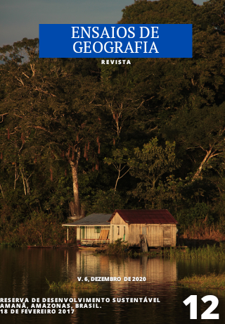
Reserva de Desenvolvimento Sustentável Amanã, Amazonas, Brasil, 18 de fevereiro de 2017
A Reserva de Desenvolvimento Sustentável Amanã é a segunda unidade de conservação deste tipo criada no Brasil, em 1998, na Amazônia Central, e está sob gestão do Governo Estadual do Amazonas. Possui estruturas de gestão e governança compartilhada entre o estado, as comunidades locais e as instituições parceiras. Está localizada no médio curso do Rio Solimões e abrange parte das bacias hidrográficas dos rios Solimões, Japurá e Unini. Esta área protegida possui uma área territorial de 2,35 milhões de hectares, conformada por ambientes de várzea, paleovárzea e terra-firme. A RDS Amanã é uma das áreas protegidas que compõem o Mosaico do Baixo Rio Negro e está inserida no Corredor Ecológico da Amazônia Central e na Reserva da Biosfera da Amazônia Central. É reconhecida como Patrimônio Mundial Natural pela Unesco (Complexo de Áreas Protegidas da Amazônia Central) e como Sítio da Convenção Ramsar de Áreas Úmidas de Importância Internacional (Rio Negro). Esta unidade de conservação de uso sustentável possui mais de cinco mil moradores e usuários que realizam como atividades principais para autossustentação e comercialização, a pesca, a agricultura familiar e o extrativismo. A RDS Amanã é ordenada territorialmente em setores que agregam comunidades e que estabelecem as formas e estratégias de uso e a gestão dos recursos naturais. A fotografia da capa desta edição foi registrada no setor Castanha, um dos 11 setores que esta unidade possui. Ela retrata as típicas habitações flutuantes da região, que são estratégicas para o modo de habitar esses ambientes que sofrem sazonalmente com as enchentes dos cursos d’água. A fotografia foi registrada em uma viagem para a realização de uma oficina com as comunidades locais, que teve como objetivo a assessoria para a organização social visando o manejo de recursos naturais e a mediação de conflitos por uso e domínio de lagos destinados à atividade de pesca. Nesta oportunidade, entre diferentes atividades e ferramentas utilizadas para subsidiar a condução da oficina, foram utilizados mapeamentos participativos para o diagnóstico de uso do território com as comunidades usuárias.
Caetano Franco
Bacharel em Geografia pela Universidade Federal de Alfenas/MG, Brasil; Aperfeiçoamento
em Manejo de Áreas Protegidas pela Colorado State University/CO, EUA; e Mestre em
Gestão de Áreas Protegidas na Amazônia pelo Instituto Nacional de Pesquisas da
Amazônia/AM, Brasil.
Contato: caetanolbfranco@gmail.com
Publicado:
22-12-2020
